


This is where the rubber meets the road.
The ambitious revitalization plan known as Riverside Rediscovered, more than a year in the making, must now be incorporated into law so that the vision laid out by planners and embraced by the community can become reality.
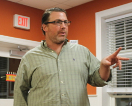
Without changes to town code and state regulations, the plan will remain just that — a plan on a shelf. For many plans, this hurdle proves insurmountable. But for Sean McLean, vice president of planning and development at Renaissance Downtowns, the firm hired by the town as “master developer,” implementation is not optional.
“This one’s personal,” McLean said at the Flanders Riverside Northampton Community Association meeting last night. Though he’s been involved in dozens of redevelopment projects, the one in Riverside hits home. McLean lives in Flanders, an adjacent hamlet whose fate and fortune are inextricably linked with the beleaguered Riverside hamlet.
“I live here. My family lives here,” McLean said, noting that the value of his own home is tied to the success of the revitalization plan.
It’s a tall order.
Riverside is “the most ignored, underserved, voiceless community on Long Island,” according to the town’s Riverside Revitalization Action Plan.
Ranked as the most economically distressed community in Suffolk County, its property values are one-third of Gordon Heights and the median income of its residents is $20,000 per year less than Wyandanch, the second and third most distressed communities, respectively.
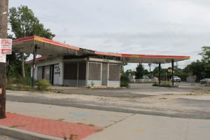
A trip to Riverside provides a visitor with open air drug markets, prostitution, litter, and a general feeling of total disinvestment. Many residents are forced to reside in deplorable housing conditions and the immediate area offers a few gas stations, a handful of local shops whose owners work very hard to stay open, and a plethora of blighted and vacant buildings. The good people who live here are a diverse working class with a rich history of acceptance and entrepreneurship. These “Champions” are holding on to what’s left of the great place they call home.”
The master developer envisions a total transformation of the hamlet, which boasts four miles of waterfront, 1,000 acres of preserved lands and proximity to “spectacular ocean, bay, sound and fresh water beaches; world class vineyards, farms, artisan food production venues and micro-breweries; live music, the Long Island Aquarium and world class shopping.”
It aims to accomplish the transformation by creating “a true sense of place, utilizing smart growth and sustainable development principles that meet the needs of current residents and attract future residents and businesses.”
The plan embodies broad-based community input gained from meet-ups and door-to-door canvassing and online campaigns, in what the developer calls its “crowd-sourced placemaking program.” Among the most popular community-chosen ideas: a riverside boardwalk, shuttle bus service, Waterfire on the Peconic, a water fountain/ice rink, a movie theater, restaurant row, waterfront green spaces, maritime trail, supermarket, farmers market.
A new zoning overlay map will create “a mixed-use and walkable Gateway Center to enhance the vibrancy of the Riverside Hamlet Center and create a diversity of uses.” The new zoning will offer “housing choices with a broad range of housing types and price points.”
The zoning overlay allows for the densest development within a quarter-mile of the Route 24 traffic circle and “scales down in density as it radiates away” from that point. The underlying zoning in the area will not be changed. The overlay is optional, with bonuses and incentives provided to landowners who opt in. To opt in to the overlay zone, a minimum lot size of 7,500 sq. ft. is required.
The development is contingent on the construction of new wastewater treatment infrastructure to serve the hamlet.
“New development cannot jeopardize the sustainability of groundwater and surface water resources,” the plan states. “Sanitary wastewater must be collected and treated before discharge to the environment.”
The zoning overlay districts proposed in the plan are detailed below. McLean said the the developer’s goal is to get the new codes adopted by the Southampton Town Board by the end of the year.
That’s another tall order — and one that drew a wry smile from Councilman Brad Bender last night.
“That’s very ambitious,” Bender said.
McLean said in order to meet that goal, the town must complete the detailed environmental analysis required by the State Environmental Quality Review Act. Nelson Pope and Voorhis has been hired to complete a generic environmental impact statement, the cost of which is being funded by a state Brownfields Opportunities Areas grant obtained by the town.
“The environment has to be better off when we’re done building than it is right now,” McLean said. “We have to demonstrate that whats being proposed works environmentally. We know it works socially and economically,” he said.
The town will hold a heading on the draft GEIS on Oct. 29, McLean said. McLean said he is working on having the hearing held at either the Crohan Community Center or Phillips Avenue Elementary School, rather than at Southampton Town Hall, to make it easier for residents to attend.
McLean is presenting the plan to the Pine Barrens Commission this afternoon at its meeting at Southampton Town Hall. Much of the property affected by the plan is in the pine barrens compatible growth area, where land use standards and regulations aimed at protecting groundwater are in place. Among those standards are land-clearing limitations and wetlands buffers and setbacks with which the proposed development will not comply.
The state pine barrens law and regulations contain mechanisms for waivers from the strict application of those standards, and allow for more leniency than those that apply in the pine barrens core preservation area, said Richard Amper, executive director of the L.I. Pine Barrens Society. He said he was not familiar with specific proposals in the town’s Riverside Action Plan or what waivers would be sought.
“Renaissance Downtowns is making an informational presentation to the commission on Wednesday, so we’ll all get to hear what they plan and what they need,” Amper said, adding that his organization has not yet taken a position on the revitalization plan. “We are listening with open ears,” he said.
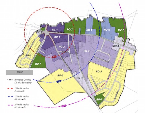
RO-1 Riverside Hamlet Center: Buildings up to 4.5 stories high on 60,000 sq. ft. lots. (Smaller buildings, up to 3.5 stories, may be built on smaller lots.)
- Create a walkable, vibrant mixed-use Hamlet Center, with compact development and a vibrant publicly accessible Peconic River Waterfront Promenade.
- Leverage proximity to natural areas & open spaces.
- Create lovable spaces with high standards of aesthetic design, walkable streets
with active frontages and on-street parking; create street enclosure. - Leverage proximity to Riverhead Downtown and Riverhead transit center, and
strengthen the connections by creating a pedestrian bridge and boardwalk loop.
RO-2 Riverside Hamlet Neighborhood: Buildings up to 4 stories high on 60,000 sq. ft. lots. (Smaller buildings, up to 3.5 stories, may be built on smaller lots.)
- Provide a range of housing options in walking distance from Hamlet Center.
- Increase permeability of blocks for pedestrian traffic and increased connectivity
for car traffic. - Allow increased density to support commercial vitality and satisfy desire to live
in walking distance to Hamlet Center. - Regulate frontages to activate streets.
- Create safer streets by increasing street enclosure, providing on-street parking,
visible crosswalks with pulled-in pedestrian refuge islands.
RO-3 Riverside Special District: Buildings up to 4 stories high on 60,000 sq. ft. lots. (Smaller buildings, up to 3.5 stories, may be built on smaller lots.)
- Provide diversity of housing options and building typologies.
- Increase permeability of blocks for pedestrian traffic and increased connectivity
for car traffic. - Regulate frontages to activate streets.
- Allow artisan production in mixed use and live-work environments. n Provide diversity of private and public open spaces.
- Provide access to fresh food, encourage and allow food production.
RO-4 Riverside Gateway District: Buildings up to 3.5 stories high on 60,000 sq. ft. lots.
- Create landscaped, architectural or artistic gateway features to announce arrival to Riverside.
- Allow cross-access or new streets.
- Create safe and walkable connections to natural areas.
RO-5 Riverside Suburban District: Buildings up to 2.5 stories on 15,000 sq. ft. lots
- Create interconnected community to increase walkability.
- Create greenways and pedestrian ways.
- Leverage proximity to educational assets and provide variety of resources. n Allow granny-flats.
- Minimize potable water use.
- Landscape with native or edible plants.
- Minimize energy use.
- Downplay and/or screen presence of parking within the private frontage.
RO-6 Riverside Waterfront District: Buildings up to 3.5 stories high on 60,000 sq. ft. lots.
- Leverage maritime resources and proximity to natural areas and Peconic River. n Create public access to waterfront.
- Connect to boardwalk and trails.
- Create economic value by leveraging on waterfront assets.
- Include waterfront and hospitality related uses.
RO-7 RPL Riverside Parkland: No development
- Leverage maritime resources and proximity to natural areas and Peconic River.
- Create a Greenways Plan that connects all waterfront with pedestrian ways,
greenways, parks and open spaces. - Create waterfront promenade and boardwalk.
- Create pedestrian trails and greenways.
- Provide parking for large parkland areas and share with adjacent Hamlet uses to minimize cost for maintenance and security, and help increase the use of parks.
Source: Town of Southampton Riverside Revitalization Action Plan, July 2015
The survival of local journalism depends on your support.
We are a small family-owned operation. You rely on us to stay informed, and we depend on you to make our work possible. Just a few dollars can help us continue to bring this important service to our community.
Support RiverheadLOCAL today.