


Today marks the start of the 2026 Atlantic hurricane season, which runs through Nov. 30, and federal forecasters are predicting a below-normal season.
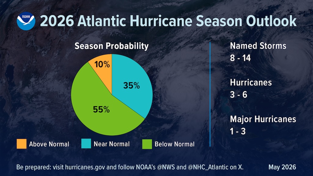
Forecasters with the National Oceanic and Atmospheric Administration’s Climate Prediction Center say there is a 55% chance of below-normal hurricane activity in the Atlantic basin this year, a 35% chance of near-normal activity and a 10% chance of above-normal activity.
NOAA is forecasting eight to 14 named storms — those with winds of 39 mph or higher. Of those, three to six are expected to become hurricanes, with winds of 74 mph or higher, including one to three major hurricanes, meaning Category 3, 4 or 5 storms with winds of at least 111 mph.
The agency said it has 70% confidence in those ranges.
The forecast reflects competing factors expected to influence the season. El Niño is expected to develop and intensify during the hurricane season, a pattern that tends to suppress Atlantic hurricane activity by increasing wind shear, making it harder for tropical storms to form and intensify. But NOAA also noted that Atlantic Ocean temperatures are expected to be slightly warmer than normal and trade winds are likely to be weaker than average, factors that can support storm development.
“Although El Niño’s impact in the Atlantic Basin can often suppress hurricane development, there is still uncertainty in how each season will unfold,” NOAA National Weather Service Director Ken Graham said in the agency’s seasonal outlook. “That is why it’s essential to review your hurricane preparedness plan now. It only takes one storm to make for a very bad season.”
For Long Island, the seasonal outlook is only part of the risk picture.
Long Island, extending eastward into the Atlantic, is exposed to tropical systems moving up the coast. While direct hurricane landfalls here are rare, the region remains vulnerable to storm surge, coastal flooding, damaging winds, heavy rain and widespread power outages.
Long Island does not need a direct hurricane landfall to experience major damage.
Superstorm Sandy made that clear in October 2012, when the massive storm — downgraded from hurricane status before it reached New York — drove devastating storm surge and flooding into Long Island, New York City and the wider metropolitan region.
In Riverhead, Sandy pushed more than three feet of standing water into downtown after the Oct. 29 high tide, flooding the Peconic Riverfront, riverfront parking areas and nearby streets. Floodwaters reached as far upland as Main Street, and coastal areas of Aquebogue and South Jamesport were severely flooded. Peconic Bay Boulevard and Hubbard Avenue were overtaken by floodwaters.
Power outages, gasoline shortages, closed roads and flooded businesses dominated the days after the storm. Downtown businesses reopened slowly, and recovery across Long Island and the New York metropolitan region was long and uneven.
More coverage: Looking back on the impacts of ‘superstorm’ Sandy: local photos and video of historic storm (Oct. 26, 2022)
The storm became a defining local example of Riverhead’s exposure to coastal flooding. Riverhead developed around the Peconic River, and much of the town’s geography is shaped by surrounding water bodies: the river, the Peconic Bays and Long Island Sound.
In the years since Sandy, flooding has remained a central issue in downtown planning. Riverhead officials have turned to the U.S. Army Corps of Engineers for guidance on how the town should address flooding along the Peconic Riverfront as it plans downtown’s future.
Although many people still refer to the 2012 storm as “Hurricane Sandy,” the National Hurricane Center had classified it as a post-tropical cyclone before it made landfall near Atlantic City, New Jersey. The distinction did little to lessen its impact on Long Island and the region.
For Riverhead, Sandy showed that the most serious hurricane-season threat is not limited to the eye of a storm crossing the Island. A large storm passing offshore or making landfall elsewhere in the region can still push water into bays, rivers, harbors and low-lying neighborhoods.
Sandy was not the first major tropical system to expose Long Island’s vulnerability.
The last hurricane to make landfall on Long Island was Hurricane Gloria, which crossed central Long Island on Sept. 27, 1985. Gloria had reached Category 4 strength near the Bahamas but weakened before making landfall in North Carolina and then on Long Island as a Category 2 storm. It still toppled trees, damaged buildings, knocked out power to hundreds of thousands of customers and left some Long Islanders without electricity for nearly two weeks.
Other hurricanes that made landfall on Long Island in the last century include Belle in 1976, Donna in 1960, the Great Atlantic Hurricane of 1944 and the 1938 “Long Island Express,” a devastating Category 3 storm that caused widespread destruction across Long Island and New England.
Long Island’s coastal risk is increasing as sea level rises and surrounding waters warm, according to the New York State Climate Impacts Assessment.
The assessment says sea surface temperature is rising around Long Island, with the largest increases occurring in summer and fall. Marine heat waves — periods of several days when water temperatures are much higher than normal — have also increased in recent years, according to the assessment.
Warmer ocean water is one of the ingredients that can fuel tropical storms and hurricanes. NOAA’s Climate.gov notes that sea surface temperatures above about 80 degrees are warm enough to help fuel tropical cyclones or hurricanes.
The state climate assessment also projects sea level along Long Island’s coastline will continue to rise this century, increasing the reach and impact of coastal flooding. Storm surge flooding worsened by sea-level rise can damage homes and businesses, cut off roads, disrupt power and contaminate drinking water supplies, according to the assessment.
The National Hurricane Center warns that storm surge is not only a beachfront problem. Its national storm surge risk maps show that storm surge flooding can extend inland from the immediate coastline in some areas.
Suffolk County maintains an interactive storm surge zone map that allows residents to search an address and see whether it falls within a storm surge evacuation zone. County emergency officials encourage residents to “know your zone” before a storm threatens.
The Greater Jamesport Civic Association will host a free New York State Citizen Preparedness Training on Thursday, June 11, from 6:30 to 8 p.m. at the Jamesport Meeting House. The session will focus on steps residents can take before an emergency occurs.
Emergency management officials urge residents to prepare before a storm is approaching.
A household hurricane plan should include how to receive emergency alerts, where to go if evacuation is ordered, how to communicate with family members and what supplies would be needed to remain safely at home without power, water, gas, phone service or internet for several days.
FEMA recommends that households have enough food, water, medication and other supplies to last several days; copies of important documents; flashlights and batteries; phone chargers; first-aid supplies; and plans for pets.
Residents should also sign up for local emergency alerts and review evacuation routes before a storm is forecast to affect the area.
The survival of local journalism depends on your support.
We are a small family-owned operation. You rely on us to stay informed, and we depend on you to make our work possible. Just a few dollars can help us continue to bring this important service to our community.
Support RiverheadLOCAL today.